
Typhoon Maysak Expected to Hit Quang Ninh Tonight
Updated on July 4 at 5:00 p.m.
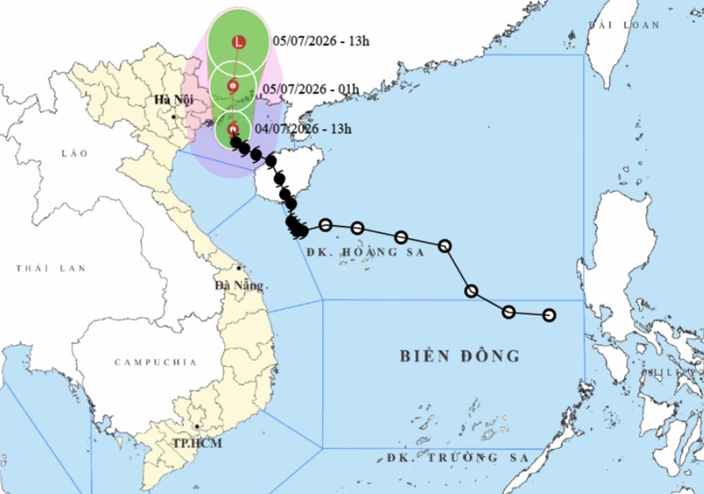
Typhoon Maysak is expected to reach the northern part of Quang Ninh Province during the night of July 4 to July 5, with an intensity of level 8 to 9 and gusts possibly reaching level 11.
At 3:00 p.m. on July 4, the center of the typhoon was located about 90 km from Mong Cai, in Quang Ninh Province. After passing near northern Vietnam, Maysak is expected to move toward Guangxi, China, and gradually weaken into a tropical depression.
Strong Winds Already Recorded
Under the influence of the typhoon, several areas in northern Vietnam have already recorded strong winds.
In Bach Long Vi, winds reached level 9, with gusts up to level 10.
In Co To, winds reached level 8, with gusts up to level 9 and waves of around 2.25 meters.
In Cua Ong, winds also reached level 8, while in Mong Cai, winds reached level 6.
The strongest winds along the coastal areas of Hung Yen, Hai Phong and Quang Ninh are expected between 3:00 p.m. and 9:00-10:00 p.m. on July 4.
In these areas, winds may reach level 6 to 7, and up to level 8 near the center of the typhoon, with gusts possibly reaching level 10 to 11.
Very Rough Seas in the Gulf of Tonkin
The Gulf of Tonkin will remain strongly affected this evening and tonight, especially around Bach Long Vi, Van Don, Co To, Cat Hai and Hon Dau.
Winds may reach force 6 to 7, and up to force 8 to 9 near the center of the typhoon. Gusts may reach force 11, with waves of 2 to 4.5 meters.
Seas will be very rough, creating dangerous conditions for boats and maritime activities.
Heavy Rain in the Northeast
From the afternoon of July 4 until the end of July 5, northeastern Vietnam is expected to see moderate to heavy rain.
Rainfall totals should generally reach 50 to 120 mm, and locally more than 150 mm.
The most exposed provinces are Quang Ninh, Hai Phong, Lang Son and Bac Ninh, where rainfall could reach 150 to 250 mm, and locally more than 400 mm.
This heavy rain may cause urban flooding, flooding in industrial zones and flooding in low-lying areas.
Risk of Floods and Landslides
Between July 4 and July 7, flooding is possible on rivers in the Northeast, with water levels rising by 3 to 6 meters upstream and 2 to 4 meters downstream.
The main risks are flash floods on small rivers and streams, as well as landslides in mountainous areas, especially in Quang Ninh, Lang Son, Cao Bang and Bac Ninh.
Key Takeaways
Typhoon Maysak is expected to reach northern Quang Ninh during the night of July 4 to July 5, with gusts possibly reaching level 11.
The main areas to watch are Quang Ninh, Hai Phong, Hung Yen, Bach Long Vi, Co To, Van Don, Cat Hai and Hon Dau.
The main risks are strong winds, very rough seas, heavy rain, flooding, flash floods and landslides.
Residents and travelers in northern Vietnam should follow official weather updates, avoid going out to sea and remain cautious in coastal, low-lying and mountainous areas.
I’m traveling from Thailand on November 30th 1:30 in the afternoon to Bangkok then about 4:30 to 6:30 to d Nang international airport and staying on the beach what should I do
bedankt voor de informatie hopelijk is alles voorbij tegen begin januari 2026
Thanks for the information provided. We are arriving to Hanoi on 3 December, visiting Halong Bay, Hoi An, Hué and Ho Chi Minh. Could you tell me if it is safe to go there? And is it possible to visit touristic sites in Hoi An and Hué?
Many thanks in advance
Thanks so much for all the detailed information you are providing here! I hope everyone will be safe and sound. We have a flight booked for Nov 8, 2025 to fly to Hue and stay there for two days and then to travel to Hoi An. I will be watching your updates closely to see if it is even a good idea to go to the central Vietnam now. Let’s see if the sights and the local business like hotels and restaurants will be even open considering the recent floods and the new upcoming threat. Thank you again and fingers crossed all goes well.